Another Story on How Those Lost Mines Stories Got Started
Hi Tom,
Glad you thought those stories were useful and no problem letting others know how and where a lot of those come from.
Mary just reminded me of one more and I know you will like this one.
A fellow from the area belonged to the local mineral club and they told him I was a good source to help identify things. We became friends over a number of visits. He loved getting out and looking for mines in the area. He lived over by Pearce, an old mining town still in the area.
One time he asked if I would go with him to look for a mine in the Cochise Stronghold of the Dragoon Mountains.
He had been told of a mine up in one canyon and had gone up looking for it but didn’t find it and wanted to see if I would go with him and use my better mine eye to find it.
We drove up to Cochise Stronghold and parked and then took the one trail he said the mine was supposed to be up. From what he had been told, the mine was high up toward the ridge near the top and there was a nice hole with ore on the dumps. We hiked and it was a pretty day and a very steep area. The trail finally played out and went off to a different area and he said he had been told the mine was up the canyon toward the top of where we were standing. The area was very steep and none of the rock I had gone past looked like it could have a mine, let alone a gold mine like he had been told.
We finally came to a steep waterfall area that had no easy way past it without equipment. We sat down on the rocks and just looked at the nice view. We had seen nice wildlife and plenty of great views but no mine.
This was when my friend told me where he had heard about this. As soon as he said it was an old Apache Woman that lived down in the canyon I let my eyes roll back in my head and knew right away what had taken place. My wife is part Apache and she had told me often of the stories the Apaches had told the white man, as they used to call us import peoples. The old woman had told my friend a story and for some odd reason, he had bought into it. The woman said that the story of the Lost Dutchman’s mine was all a hoax by the Indians to get a lot of white men out looking for it and then die in the rough and unforgiving terrain.
She told my friend that the Lost Dutchman mine was actually a mine toward the top of the Dragoon Mountains and the Indians had told the story of it being in the Superstition Mountains to fool people into not looking where it “really” was, here in Cochise Stronghold. I was ticked at him for having dragged me on a total wild goose chase and remarked that the old lady had gotten back a bit at a stupid white man to go looking for a total story that she had made up.
All I could tell him was that at least it was a pretty day and a good day for a hike but I also informed him that I would never join him on any of his wild goose chases again. I told Mary of the whole tale and she agreed, the woman had found another sucker to go on chasing for gold.
There are a ton of these stories and you are welcome to use this any way you like.
In retrospect it was kind of a funny situation and he did say that he didn’t want to tell me before we went up on the mountain because he knew how I would react, he was right, I never would have gone if I had known where the story came from.
Rolf
—
Bob Ward spent 30 years in the Superstition looking for the Old Dutchman Mine and his theories (or mad guesses) are still in print.
This draft is from my now dead book project. The images were not intended to violate copyright but to guide my publisher in making new ones. My ex-publisher.
The term geological province isn’t favored anymore, instead, scientists like physiographic or something similarly stilted. I don’t.
Scientists disagree on the borders, names, and numbers of provinces within a state or region. I won’t settle their arguments here.
Macrostrat.org’s interactive map tells you what province your area of interest is in. Their free smartphone app gives you a province name for any ground you are standing on in the field. Provided you have cell phone coverage.
I Geological Provinces of The Southwest — The Lay of the Land
The American Geological Institute defines a geologic province as a large region characterized by similar geologic history and development. [Robert Bates and Julia Jackson. Dictionary of Geological Terms (New York: The American Geological Institute, 1984), 207] These characteristics include landforms, natural features of the earth’s surface, rock types, or a shared evolutionary history. Every part of the Southwest belongs to a distinct province with particular landforms and geology.
Geologic provinces show well on maps but are often hard to tell in person. No colors or lines on the ground mark one region from the other. Earth scientists may disagree where boundaries lie. Plants are sometimes better indicators than rocks. Saguaro cactus herald arrival in the Sonoran Desert. A lessening of creosote bush and an increase in sagebrush marks the beginning of the Great Basin Desert. Maps, guidebooks and a little study make these provinces stand out.
II Arizona
Arizona is the sixth largest state in America. It covers 113,909 square miles. New York, Indiana, and Maryland could easily fit inside Arizona’s borders. The state is landlocked, although the Colorado River flows through Arizona to the Pacific Ocean. The state has three distinct topographical areas.
-The Colorado Plateau
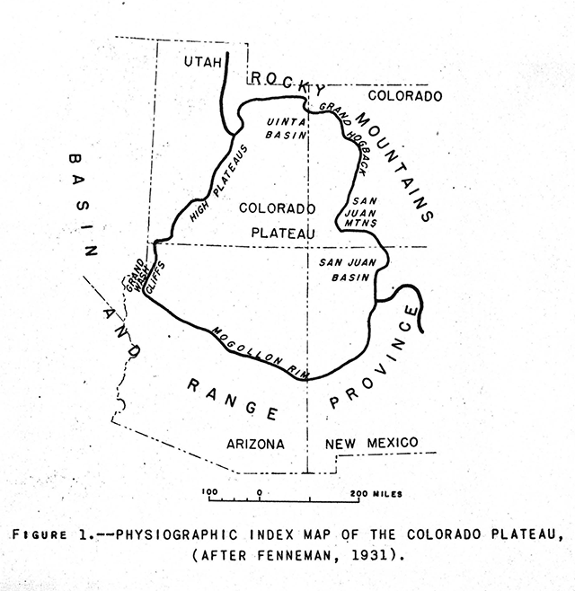
The Colorado Plateau in Arizona runs diagonally northwest southeast through the upper half of the state. Sometimes referred to as the Colorado Plateau Province, this lifted topographical feature extends into Utah, Colorado, and New Mexico. The Plateau may be pictured as centered over the Four Corners of the United States. Its elevation is between 5,000 and 7,000 feet and it covers some 240,000 square miles. [“Colorado Plateau Province” https://www.nps.gov/articles/coloradoplateaus.htm Accessed 08/08/2023]
Any map depicting gold, silver, or copper deposits in the Western United States shows a lack of these minerals in the plateau. That’s because, as Jim Straight puts it, “Both the Columbia and Colorado Plateau are capped with non-metalliferous basaltic flows.” [Straight, Jim. Advanced Prospecting for Hardrock Gold 4th edition (Rialto, California: Jim Straight, 1998) plate No. 1] In other words, ancient lava flows not enriched with precious-metal bearing minerals. This can include non-metal bearing minerals as well, such as fluorite. This holds true for each portion of the four states in the Colorado Plateau.
(The Colorado Plateau across four states)
Arizona’s largest city in The Plateau is Flagstaff. The Hualapai, Navajo and Hopi are among tribes with reservations on this land. The Plateau features much of Monument Valley, the background for many famous John Ford films. The four thousand food wide Meteor Crater lies a short distance from Winslow. In addition, the Grand Canyon wends through the Plateau. Precipitation averages 10 inches annually. Native grasses and scrub cover much of the Plateau, leaving it suitable for grazing. Junipers and pinion trees occupy higher elevations.
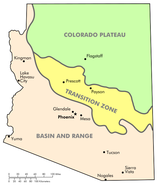
-The Transition Zone
Arizona’s Transition Zone or Highlands also runs diagonally in a southeast to northwest fashion, occupying the middle of the state. It is a narrow, mountainous region with many peaks between 9,000 and 12,000 feet. Annual mountain precipitation averages between 20 and 25 inches. This belt separates the northern plateau from the southern deserts. The largest city here is Prescott at 5,368 feet. Numerous Wilderness Areas exist in the Transition Zone along with several National Forests, state park land and a National Monument.
The notable Mogollon Rim divides the Colorado Plateau and the Highlands as it strikes across the entire state of Arizona. This long cliff does not always present itself clearly, but at times it looms 2,000 feet above lower ground like the Tonto Basin. It also plays a part as a weather maker as explained in my weather chapter.
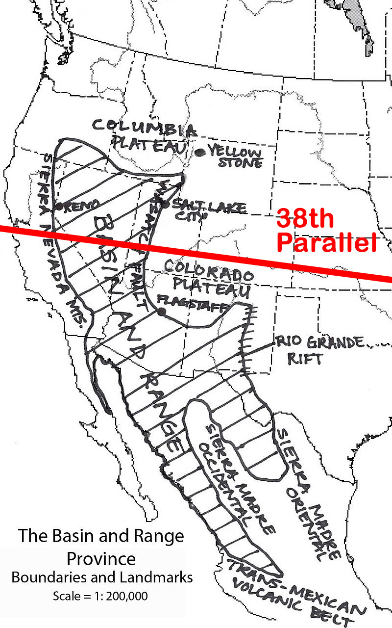
-Basin and Range
The Basin and Range geographic province reaches across vast areas of the Southwest, especially to Nevada. In Arizona, Basin and Range extends across the lower third of the state, dominated by the Sonoran Desert. Most motorists see Basin and Range as an unceasing crossing of low mountain Ranges and desert valleys. The National Park Service, however, is relentlessly positive. As they once put it, “The Basin and Range province has a characteristic topography that is familiar to anyone who is lucky enough to venture across it. Steep climbs up elongate mountain Ranges alternate with long treks across flat, dry deserts, over and over and over again!” [“Geoscience Concepts” NPS. Language now removed. https://www.nature.nps.gov/geology/education/concepts/concepts_basinrange.cfm]
Besides the name Basin and Range, these alternating peaks and valleys are also called horst and graben. These two elements make up a particular rift landscape. Horst and graben occurs when the earth’s crust is stretched up to 100% of its original size. This stretching does not go smoothly. Instead of producing a flat plain when stretched, blocks of the earth’s crust are pulled up and down. Horst and graben creates blocks of the earth’s crust and upper mantle uplifted at angles. These uplifted angles represent fault lines which underlie the topography of Basin and Range.
Within Arizona’s Basin and Range Province lies the Sonoran Desert. It is a complex of low mountain ranges and desert valleys, with annual rainfall of three to four inches. This country is normally no higher than 500 to 2,000 feet in elevation. Basin and Range here is an extension of the Sonoran Desert of Mexico. Arizona’s other desert is the Chihuahuan. It, too, originates within Mexico, although Arizona’s portion wanders in from New Mexico, intruding only into the southeast corner of the copper state. It is in this arid and alternating geologic province of Basin and Range that Arizona’s major cities lie. Kingman, Phoenix, Yuma and Tucson are all denizens of the desert.
(Arizona’s geologic provinces)
III California
-Introduction
For this book, the Southwest reaches to the Pacific Ocean. California deserts feature great rockhounding areas and must be recognized. Extending the Southwest to the Pacific also allows San Diego County to be included, the center of tourmaline mining in the greater Southwest.
-The Mojave Desert
This is the land of the Joshua Tree, as much as the Sonoran Desert is the land of the Saguaro. The two rarely intergrade, each keeping itself to one side of the Colorado River. The Mojave is home to Death Valley, which at one point lies 276 feet below sea level. Death Valley and the Mojave Desert are the hottest and driest parts of California. Rainfall sometimes measures under two inches a year. Lower than the Great Basin, elevations average between 3,500 and 4,000 feet. Californians call this the High Desert.
-The Colorado Desert
The Colorado Desert is a smaller part of the much larger Sonoran Desert. The Colorado covers approximately 7 million acres. It is dominated by the off-limits Chocolate Mountains, over which the military has an aerial gunnery Range. The desert encompasses Imperial County and reaches into the counties of San Diego, Riverside, and part of San Bernardino. The Salton Sea lies on its west side, Bombay Beach its central hamlet. Most of the Colorado sits below 1,000 feet, with below sea level elevations at the Salton Sea.
-Basin and Range including The Great Basin Desert
High, dry, and often cold, the Great Basin Desert reaches from California’s eastern border to touch Oregon and Idaho, most of Nevada, and a significant part of Utah. Elevations range from 4,000 to over 14,000 feet in the White Mountains and the eastern Sierra Nevada. The long-lived Bristlecone pine hangs to life in its montane setting while common sagebrush populates the lowlands below. No water from the Great Basin Desert runs to the sea. At the limit of the Southwest, Bishop, California at 4,150 feet represents the largest California city within the Basin.
-The Peninsular Ranges
“The Peninsular Ranges geomorphic province consists of a series of mountain Ranges separated by long valleys, formed from faults branching from the San Andreas Fault.” So states the California State Park System. [Geological Gems of California State Parks – GeoGem Note 46 -Peninsular Ranges Geomorphic Province https://www.parks.ca.gov/pages/734/files/GeoGem%20Note%2046%20Peninsular%20Ranges%20Geomorphic%20Province.pdf Accessed 08/04/2023] From a political boundary sense, the Peninsular Ranges originate at the Mexican border where both the United States and San Diego County begin. More accurately, though, the Peninsular Ranges extends south across the border to form the backbone of Baja California.
-The Transverse Ranges
The USGS states, “The Transverse Ranges Province of southern California is so-named because the mountains, valleys, and geologic structures within this province lie east-west or ‘transverse to’ the prevailingly northwest-trending grain characteristic of southern California.” [“Geologic Setting of the Transverse Ranges Province” https://geomaps.wr.usgs.gov/archive/socal/geology/transverse_ranges/index.html Accessed 08/06/2023] They also say that two other provinces of southern and central California trend northwest. Basin and Range in Nevada and New Mexico also trends in the same direction.
IV Southern Colorado
-Introduction
This book treats the southernmost portion of Colorado, at the northern edge of the Southwest. Major cities are Creede at 8,838 feet and Durango, at 6,523 feet. These high elevations mean a true four-season climate, compared to the two-season climate most of the Southwest enjoys. Snow can fall in October in Creede, with 71 days of snow each year. Snow falls later in Durango.
-Colorado Plateau
Colorado’s western portion of the Plateau includes these National Monuments: Canyons of the Ancients, Yucca House, and Chimney Rock. Western Colorado is uranium country. Most occurrences, though, exist north of this book’s Southwest border. Southern Colorado rock collecting sites are many and for varied materials Richard Pearl describes Colorado as more mineralized than any other state except California.
-Great Plains
The High or Great Plains province covers eastern Colorado. Elevations reach 6,000 feet in this mesa-like area. The High Plains are a part of a larger plains system called the Great Plains. That ranges through southeastern Wyoming, southwestern South Dakota, western Nebraska, eastern Colorado, western Kansas, eastern New Mexico, western Oklahoma, and south of the Texas Panhandle. Essentially, the eastern side of the Rockies.
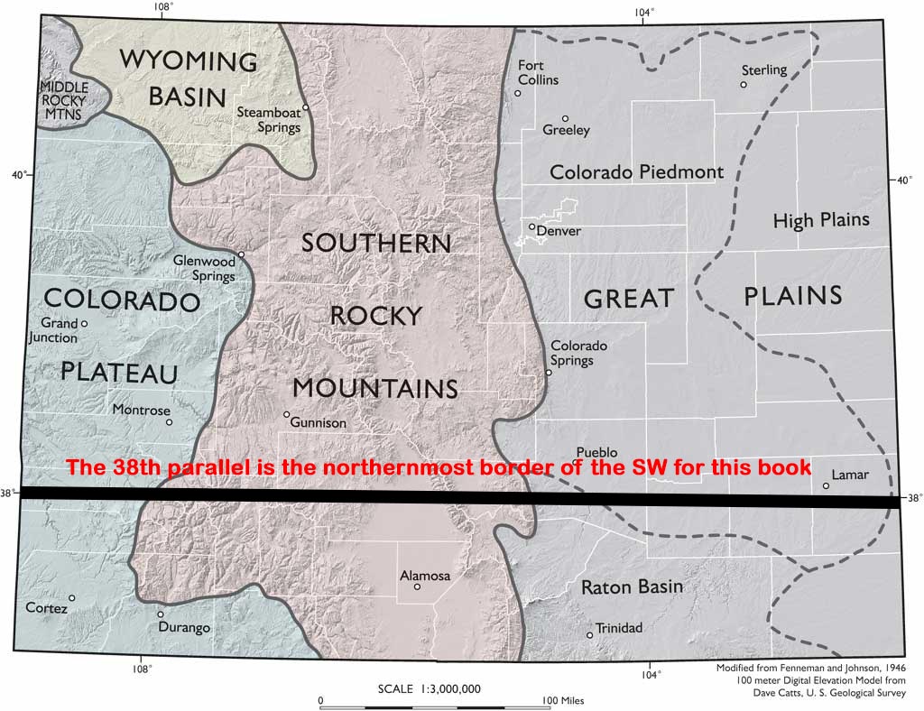
-Southern Rocky Mountains
The Southern Rocky Mountains Province in Colorado continues to New Mexico. Wedged in the lower middle of this province is the Rio Grande Rift Province. It also continues to New Mexico, the Rio Grande River accompanying it. Alamosa is the chief city here at 7,543 feet, the prominent geologic feature the broad San Luis Valley. This valley approaches the size of Connecticut. It is 125 miles long and 65 miles wide, its mean elevation 7,000 feet. Though the country is a semi-arid plain, surface and subsurface water from the Rockies allows a thriving farming community as well as sourcing the Rio Grande.
(Geologic map of Colorado showing Rio Grande Rift)
(Geologic map of Colorado, not showing the Rio Grande Rift)
V Southern Nevada
-Introduction
Nevada is Basin and Range country, north-south trending mountain ranges fixed in parallel fashion across the state. This Basin and Range landform runs from Oregon to Mexico, capturing all of Nevada with it. The Great Basin, as it is known when referring to its entirety, consists of 160 mountain Ranges and 90 Basins.
-Basin and Range
Mountain ranges march unceasingly across Nevada, accompanied by many Basins or low-lying areas. This is not a violent landscape and the motorist driving east-west will little notice. To the rockhound, however, each new mountain Range presents new road cuts and interest heightens each time a Basin’s floor is left behind.
Nevada’s mean elevation is 5,500 feet. This produces a high, dry, mostly cold desert, reflecting the same condition this landform brings to parts of southern California. For Las Vegas, the chief city of southern Nevada, rain is a scant four inches a year, with summer temperatures often exceeding 105 degrees. Nevada is the driest state in America. It averages only nine and a half inches of rainfall a year.
(Southern Nevada, not showing Arizona’s Transition Zone)
(Nevada’s many basin and ranges.: http://crack.seismo.unr.edu/graphics/Maps/nv-topo.jpg)
VI New Mexico
-Introduction
New Mexico is the fifth largest state by area in the United States. It totals 121,412 square miles. The federal government owns 35% of that territory. 14,062 square miles is in National Forest and approximately 20,312 square miles in BLM lands. New Mexico’s twenty-three Indian tribes own or control 5,739 square miles.
The state’s topography is varied and dramatic. Scenic gorges, mesas, high plateaus, canyons, valleys, and dry washes or arroyos are all part of New Mexico. Average elevation is about 4,700 feet. The lowest point is just above the Red Bluff Reservoir at 2,817 feet where the Pecos River flows into Texas. The highest point is Wheeler Peak at 13,161 feet. 23 Indian tribes exist in New Mexico. That includes nineteen Pueblos, three Apache tribes (the Fort Sill Apache Tribe, the Jicarilla Apache Nation and the Mescalero Apache Tribe), and the Navajo Nation.
(New Mexico geological provinces)
-The Southern Rocky Mountain Province
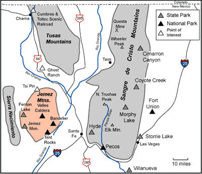
The Southern Rocky Mountain province is by definition mountainous ground considered part of the Southern Rocky Mountains. The Sangre de Cristo Mountains, the Tusas Mountains, and the Sierra Nacimiento are included in this grouping. They lie on either side of the Rio Grande Rift Province.
The southern end of the Sangre de Cristo Mountains terminates near Santa Fe; this mountain Range marks the western edge of the Great Plains. The Range continues northward for some 200 miles until Salida, Colorado. Herbert Ungnade wrote that, “The Sangre de Cristo Mountains were hunting grounds for Apache and Comanche Indians and that the Spaniards ventured into them only in heavily armed groups.”
The Southern Rocky Mountain Province contains some of the highest peaks in New Mexico. Like the aforementioned 13,000-foot Wheeler Peak. Lower country exists as well. Like the Questa Caldera in the Sangre de Cristo Mountains northeast of Taos. Calderas are ancient basin shaped volcanic depressions, collapsed volcanoes, and this one sits at approximately 7,400 feet. Of special note is the ancient Valles Caldera National Preserve near Bandiler. Looking deceivingly like a flat grassy field, the caldera is actually a thirteen-mile wide depression supporting meadows, wildlife and wandering streams. Bandelier National Monument and Pecos National Historical Park nearly align on the same geographic parallel. They two points effectively serve as the southernmost reach of the Southern Rocky Mountains Province.
(The Southern Rocky Mountain Province, not showing the Rio Grande Rift Province which is in the middle, following the Rio Grande River.)
-The Colorado Plateau
The Colorado Plateau in New Mexico lies in the upper northwest corner of the state. New Mexico’s two major cities, Santa Fe and Albuquerque, lie on the edge of its borders. Their elevations are 7,199 feet and 5,312 feet, respectively. As noted in the description of Arizona and Colorado, the Colorado Plateau Province’s 130,000 square miles is lodged squarely over parts of the Four Corners States. The Navajo Nation also owns much territory in the Colorado Plateau of New Mexico. They in fact own 27,000 square miles in the Four Corners region, an area larger than West Virginia. The rich topography of the plateau partly explains the nine National Parks and eighteen National Monuments located there.
(New Mexico’s density of parks)
-The Rio Grande Rift Province
The Rio Grande Rift Province splits New Mexico in two, with the Rio Grande River running down the middle. The rift begins high in the Colorado Rocky Mountains near Leadville, Colorado. It terminates in the Mexican State of Chihuahua close to Ciudad Juárez. Its stateside length is over 600 miles. The rift is not a valley or canyon caused by erosion from the Rio Grande River. Instead, the zone is a tearing down and building up of the earth’s crust. The Colorado Plateau pulls to the west, the High Plains to the east. This action is from two parallel fault zones that run north-south through New Mexico.
(New Mexico’s Rio Grande Rift Province)
-Basin and Range Province
Basin and Range topography in New Mexico occupies the lower southwest portion of the State. This same geologic occurrence extends from Mexico to Canada. [Christiansen, Eric and Kenneth Hamblin. Dynamic Earth: An Introduction to Physical Geology (Burlington, Massachusetts: Jones & Bartlett Learning. 2015) 592 ] Southern Arizona, eastern California, southern Idaho, western Utah, and most of Nevada. Again, Basin and Range is marked by mountain Ranges striking in a northerly to northwest fashion, alternating with wide Basins.
(New Mexico’s Basin and Range Province)
-The Mogollon-Datil Province
Experts think the Mogollon were an ancient Indian tribe inhabiting what is now eastern Arizona and western New Mexico. The area is geologically complex. Within the province is the Mogollon-Datil Volcanic Field. Numerous calderas populate the area, especially in the Gila Wilderness. The Mogollon Mountains rise to 11,000 feet. The Continental Divide is represented, between the Gila and the Rio Grande Rivers.
(New Mexico’s Mogollon-Datil Province)
-The Southern High Plains or The Great Plains
The High Plains province covers New Mexico’s eastern quarter. Elevations reach 4,000 feet in this mesa-like area. The High Plains are a part of a larger plains system called the Great Plains, its reach described in the Colorado section. The High Plains includes part of the Permian Basin, which is fueling an oil and natural gas boom in this mostly flat grazing country. The Permian is located in the south-east corner of the state near the Texas border. The High Plains Province also hosts part of what is called the late Miocene-Pliocene Ogallala Formation. It is a major aquifer in the United States. Larger cities include Hobbs, Lovington, and Carlsbad.
(New Mexico’s Southern High Plains or Great Plains)
VII Southern Utah
-Introduction
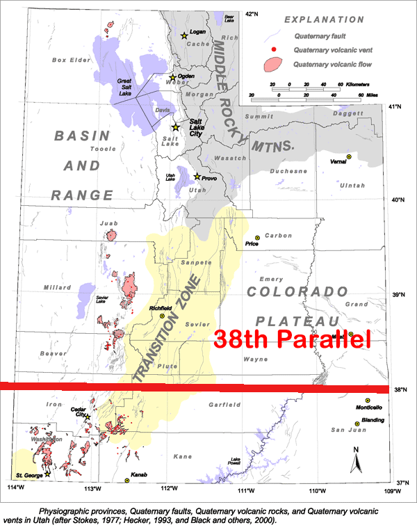
Three major geologic provinces make up Utah. Basin and Range and the Colorado Plateau exist in Utah as they do in other states. The third is the Middle Rocky Mountains province which lies outside the Southwest. Some geologists also place a Transition Zone in Utah, which will be included for completeness.
-The Transition Zone
This Province is included as a Geologic Province of Utah by some and not by others. It is poorly defined, placed somewhere between Basin and Range to the West and the Colorado Plateau to the east. The largest city in the Zone and in Southern Utah is St. George, at an elevation of 2,860 and a population of 82,318. It is home to the St. George Dinosaur Discovery Site at Johnson Farm, a museum and locality that preserves a Jurassic era lake ecosystem. The next biggest town is Cedar City at 5,846 feet and a population of 31,223. This area is close to the Dixie National Forest. Within that forest, agate collecting goes on near Panguitch Lake.
Utah’s topography is mostly mountainous but varied. Almost 80 mountain ranges lie within or partially within it. The state’s highest point is 13,498-foot-high Kings Peak in the northern Uinta Mountains. Southern Utah mountain ranges climb to 8,600 feet or so.
-Basin and Range Province
Utah mountain ranges are typically 12 to 31 miles apart and 28 to 50 miles long. [“Physiographic Regions of Utah” https://geology.utah.gov/popular/general-geology/utah-landforms/geologic-provinces/ Accessed 08/10/2023] Utah mean elevations reach 4,000 to 7,000 feet.
St. George and Cedar City both lie at the edge of Basin and Range, close to the poorly defined Transition Zone which separates Basin and Range from the Colorado Plateau. Viewed with Google Earth, Basin and Range levels off as it approaches the two cities. Proceeding east after that, the Colorado Plateau appears as a sparsely vegetated mesa.
-The Colorado Plateau
Southern Utah’s notable geologic features include plateaus, buttes, mesas, and deeply scored canyons. Utah’s lower southeast is the Four Corners area, distinguished by the Colorado Plateau. Monument Valley extends here into Utah from Arizona. Tribal land also exists on which no collecting is permitted without permission.
-The Colorado Plateau’s Great Basin Section
The Great Basin Section’s central feature is the Colorado River which eventually flows into Lake Mead near the Nevada border. The Green River makes up the Colorado’s principal tributary. Its drainage or watershed begins in northern Utah, northern Colorado, and southern Wyoming. Many cities in the arid Southwest, especially Las Vegas, Nevada, depends on water originating high in the Rocky Mountains.
This is a link to Wikimedia Commons to one of my pictures of the Indian/Rainbow Rock Shop in Holbrook, Arizona. Copyright free. You can investigate the link to see more details about the photo.
NB: Short URL for this page: https://wp.me/p9Ykms-Mn — Friday at the QIA PowWow and Desert Gardens
Day Three of the QIA PowWow greeted everyone again with perfect weather. Cool mornings and then long sleeve shirt weather in the afternoon. Wind picking up later in the day but no more than a breeze. —
Day Three at The QIA PowWow 2020 from Thomas Farley on Vimeo. — Although I was trying to keep focused through the day, my mind kept returning to a location I discovered halfway between Parker and Quartzsite while investigating railroad ballast. (external link) My gold prospecting spidey sense kept tingling. Yes, I may be talking to you. But I’d rather leave to sample some black sand. Gold fever is a true sickness. (internal link)
I was at the PowWow only long enough to exchange a piece of eudialyte that I had bought the day before from Alexander BlagulaAll of the previous night my purchase had bothered me. I had settled for what I could afford, not the cab I truly wanted. Before heading to Quartzsite I stopped at Wells Fargo in Parker to get the extra money I needed. Alexander seemed happy to see me, as I think he knew what I wanted to do. With graciousness he took back my first stone and gave complete credit for the new cab. In the way he talked and acted, I got the feeling that he was glad I was buying his best material. This video is from the day before. —
Alexander Balagula of Unique Russian Mineral from Thomas Farley on Vimeo. —
Desert Gardens
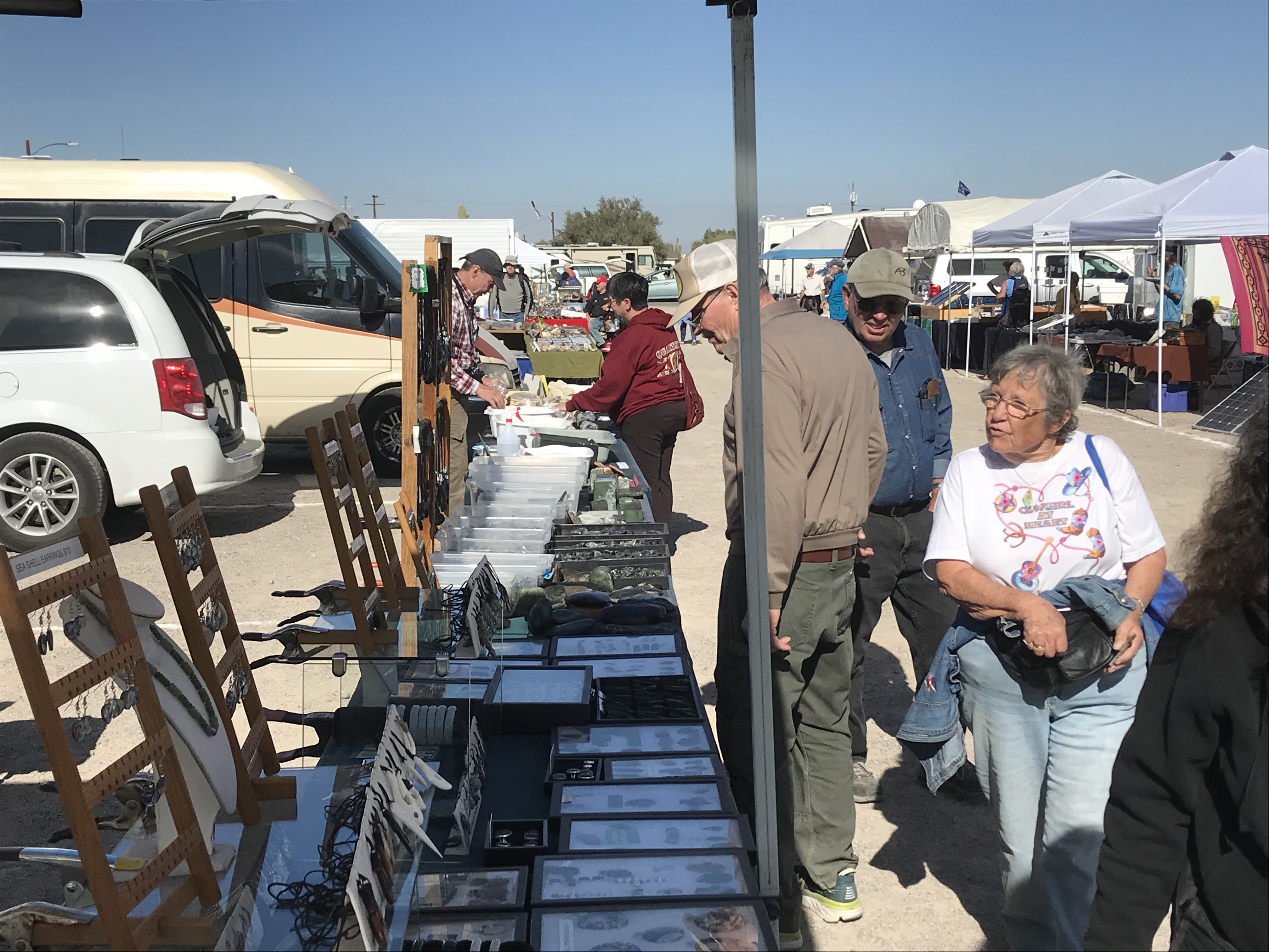
I took a few videos of the crowd at the PowWow and then moved across I-10 to Desert Gardens. To make it there, I used the frontage road as I had always done. Before you get to Desert Gardens, however, you have to pass through the Tyson Wells venue area. That venue sells a variety of things, not just rocks. It was complete madness, just looking at the teeming crowds put me nearly into a panic attack. I couldn’t imagine anyone voluntarily entering that swarm yet hundreds, if not thousands, seemed happy to do so.
Once at Desert Gardens things calmed down. The aisles are wider than the PowWow, making it seem more relaxed. The food, though, expect for the hot dogs, was limited and disappointing. I think the food is prepared by vendors who pay to be there, rather than cooked by happy volunteers. I’d bring your own food as you will probably be wandering for several hours. The big rocks are here, especially of rough of all kinds. Every vendor was from somewhere different, each had their own story and their own experiences. Each was an expert on at least several of the rocks or minerals they were selling. They all have their favorites, although they are often hesitant to name them. A number of fluorescent mineral dealers were at Desert Gardens. I didn’t see any radioactive minerals.
The first folks I met were at P.V. Rocks. Gary Peavy owns this business and he hails from Peoria, Illinois. He does some regional shows but once a year he gets out to Quartzsite. Wide variety of materials with much from the Midwest. E-mail is [email protected] and his website is https://pvsrocks.com. —
PV’s Rocks at Desert Gardens, Quartzsite, 2020 from Thomas Farley on Vimeo.
— I was finally able to meet up with R.C. of Geological Specimen Supply (external link). He hand carried my latest order to me, rather than posting it as usual. Just what I needed, another box of rocks. He pointed out T-Cat in his van. R.C. always takes a cat collecting with him. He had been looking at PowWow for what I used to call peridot in vesicular basalt. I think he is saying it is actually peridotite xenolith in basalt. I think. I always have to read up on what R.C. says to me. It’s a great learning experience. He answered some of my pesky rock questions and seemed interested in the crazy looking railroad ballast I had seen near the La Paz County Fairground. Yes, rockhounds and geologists are interested in railroad ballast. —
I also caught up with the Keadys of Rockchuck in Schurz, Nevada. (external link) I’ve written extensively on them before. Chelsea is continuing lapidary while awaiting the birth of her first child. I have their video on a previous page, but, what the heck, here it is again.
The Keadys of Rockchuck in Schurz, Nevada from Thomas Farley on Vimeo.
—
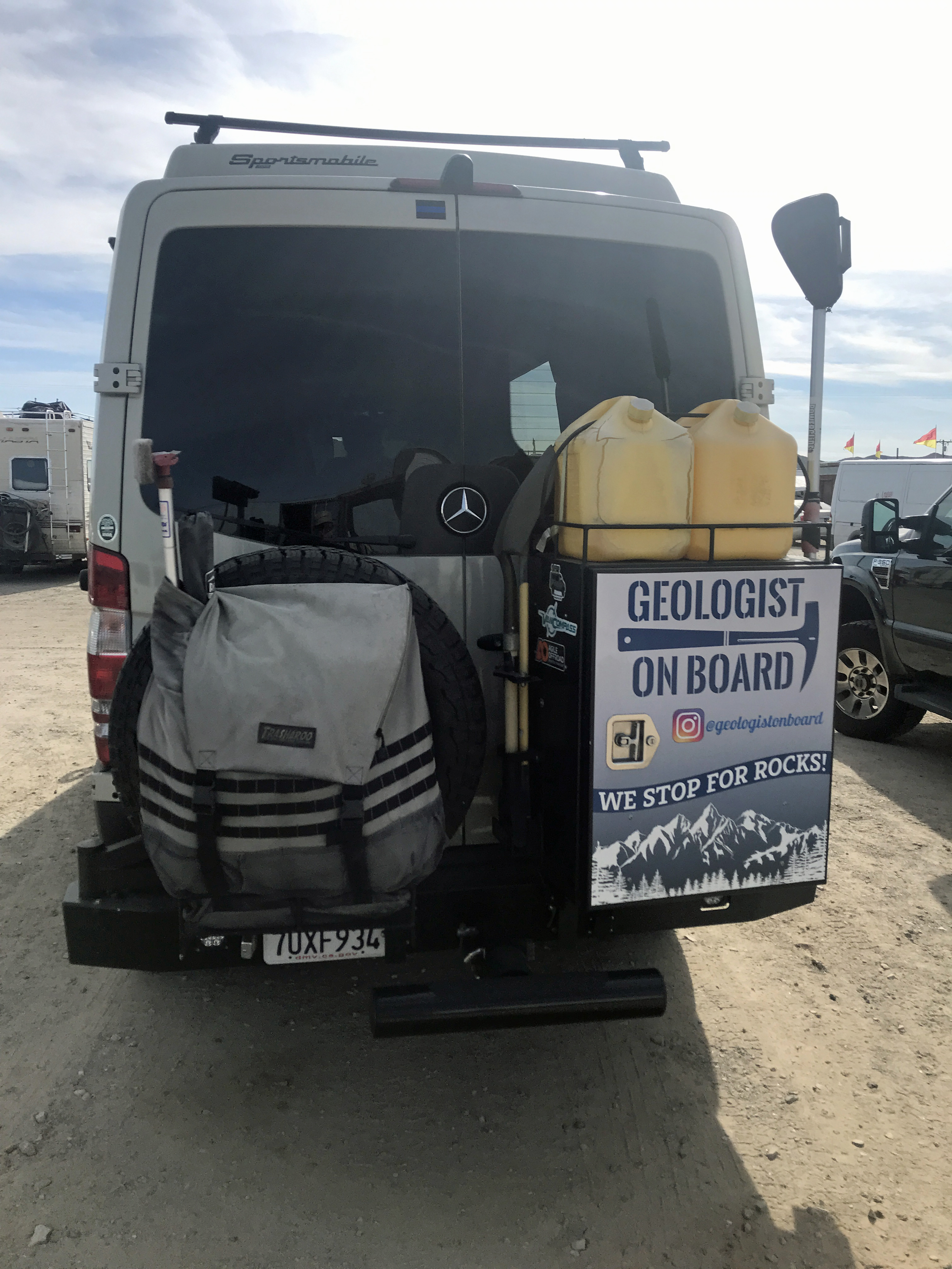
After many tries, I also managed to find Laura Fitzpatrick, otherwise known as #geologistonboard. She is an Instagram influencer, who has thousands of followers. She writes extensively and in depth on geology and travels the world with her husband hunting and investigating everything rock related. She recently toured the Himalayas, reporting on each step of the way through Instagram. It’s all about the Gram. She agreed to an impromptu interview inside her well kitted Geo Mobile, a specially outfitted four wheel Mercedes van. She turned out to be a real gold bug and marvelled over my gold in quartz jewelry, insisting on taking pictures of the pieces. I tried not to bore her with my prospecting stories but she followed every detail of my accounts. Through the internet she is helping thousands learn about geology and to give people accounts and pictures of places most of us will never see. #geologistonboard
Geologist on Board in The Geo Mobile AKA Flint from Thomas Farley on Vimeo.
— I also talked with David Bintliff of the Rock Broker. See the video below. My big regret was that I did not stay or ask that he light up these rocks. I tried to make it the next day but bridge traffic was terrible. If you meet David, he does have lamps on site and I am sure he will show you what is happening with these multi-mineral, multi-UV colored rocks.
David Bintliff of the Rock Broker. 605-593-6012.
David Bintliff of the Rock Broker at Desert Gardens in Quartzsite, Arizona from Thomas Farley on Vimeo.
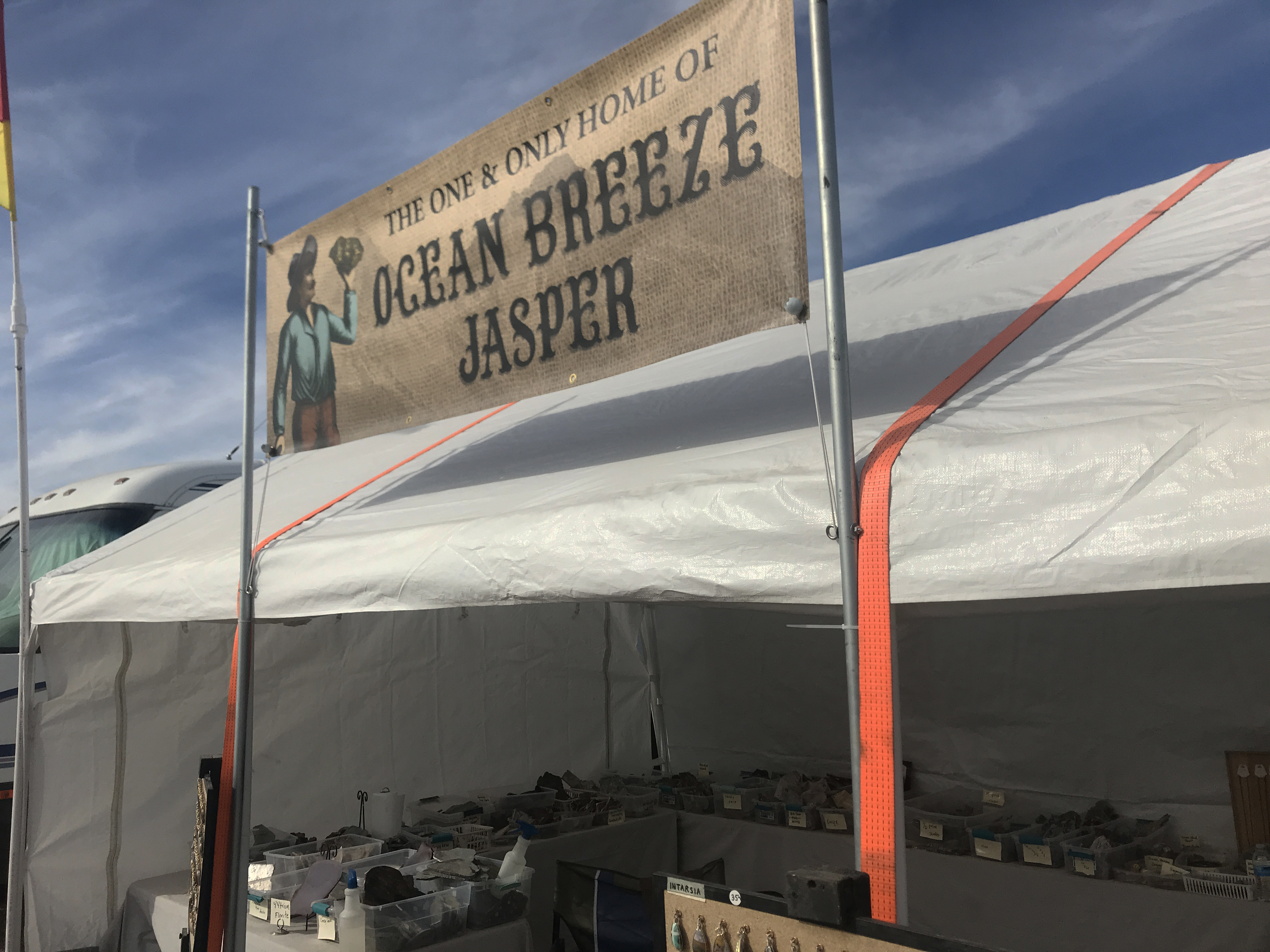
— It was a treat, too, to meet the folks at Jim’s Rough Rocks who have a banner proclaiming Ocean Breeze Jasper. Their Facebook page is here: https://www.facebook.com/JimsRoughRocks/Ocean
They are from Redmond, Oregon. Not the Redmond in Washington State, home to Microsoft, but Redmond, Oregon. I messed up on the video and misstated their business name. Apologies. Will try to fix.
Jim’s Rough Rocks at Desert Gardens in Quartzsite. 2020. from Thomas Farley on Vimeo.
— A few more hours in Quartzsite tomorrow and then I head off Saturday afternoon for Kingman, Arizona. Stay tuned. —
Pow Wow Show Promoters Mike & Carolyn Zinno 928-927-6325 [email protected]
Quartzsite Improvement Association 235 E. Ironwood Avenue, Quartzsite, AZ 85346 http://qiaarizona.org
You can read more about Quartzsite at Rock&Gem’s website and Facebook page. (external link). I was covering the day to day at the PowWow for them this year and I have written extensively on all things Quartzsite in the past. —
Follow me on Instagram: tgfarley
https://www.instagram.com/tgfarley/ Follow me on Instagram: tgfarley
Thursday brought another day of beautiful weather to Quartzsite. A few wisps of clouds appeared from time to time, somewhat relieving the sun’s powerful glare. Temperatures rose into the high 60’s in the afternoon, shirt sleeve-weather but best taken in with a long sleeve shirt to prevent sunburn.
The day got warm enough that an alert went over the public address system about a few dogs that had been left in cars. Their owners were told to get back quickly to their vehicles before the police started breaking windows. This brings up the matter of dogs at Quartzsite – they are all over.
On a leash, hand carried, or in a stroller, big dogs and little dogs are all about the aisles at the PowWow. I’ve never seen a dog fight but there are occasional lunges and a few sharp barks. Young dogs are around that may not be used to crowds and there are tiny dogs that are vulnerable. Every owner I saw seemed to have a dog that was socialized or mostly so. The dog community is fully present at the PowWow as you hear constant compliments from people on each other’s dogs. Big dogs seem to draw the most likes.
I could only visit a few vendors as I got wrapped up in long talks with each about their materials and collecting. I met quite a few people who knew people who I knew. One example was Kirk Brock at Rock Solid Jade at space 490. I showed him my jade key fob to see if he could identity its locality. He thought it most probably nephrite from Mendocino County in California. I said I carved it in Hesperia at the Mining Supplies and Rock Shop during a jade carving class taught by Mariana Shoupe. “Oh, yes,” Kirk said, I know her quite well. I think she is here now at the show. ”
This video looked great on my phone but it and a few others changed from landscape to portrait layout. I’ve attempted to rescue it with a frame.
Rock Solid Jade with Kirk Brock from Thomas Farley on Vimeo.
— Another example was when I fell into two people who kept mentioning Utah locations for agates. I then noticed that one had a Southern Utah Rock Club hat on. “I’m a member!”, I exclaimed. “I know Lynn. He showed me a great place for field agates that I would never have found otherwise.” They smiled and said they knew this place near Cedar City well. The couple lived in Mesquite, Nevada and when the weather got too hot they would drive to that higher elevation to collect during the summer. This conversation took place at the space for Johnson Brothers Lapidary. https://www.johnsonbrotherslapidary.com
— I’ve written that you’ll never know who you’ll meet in Quartzsite. Proof of that was when I stopped at Mike Martin’s space, number 239 and 240. Lots of fossils. I am not a fossil guy but I know they are popular and I haven’t covered fossils. So, I asked for permission to photograph and started asking questions. He looked at my business card and started repeating my last name. “Farley, Farley, Farley.” I thought perhaps he had read one of my articles for Rock&Gem. Instead, he asked if I had any relatives in Humboldt County, California. I started to cry but held back my tears. “Just my late brother.” “That was Tim! Biff Barker! He worked for me when I owned the radio station in Eureka. He was great. Everybody loved him. Great sense of humor.” Tim worked a long time in radio and Eureka was where he found a home. He did morning drive and was absolutely fun to listen to. Mike allowed Tim to be himself and it was a very emotional time for me as we both exchanged memories of my past brother. Mike, by the way, does an enormous amount of self collecting and coin and relict hunting in England. Well worth a stop.
Mike Martin / Detector and Fossil Sales from Thomas Farley on Vimeo.
— Inside the main hall are displays and, as always, the Ottesens. I didn’t get a chance to ask them about how they are restarting the fee digs but they are. I’ve been out to the Royal Royston for my first Rock&Gem article and also to their Broken Arrow claim last year. Both terrific experiences. https://ottesonbrothersturquoise
Inside the QIA Main Building from Thomas Farley on Vimeo.
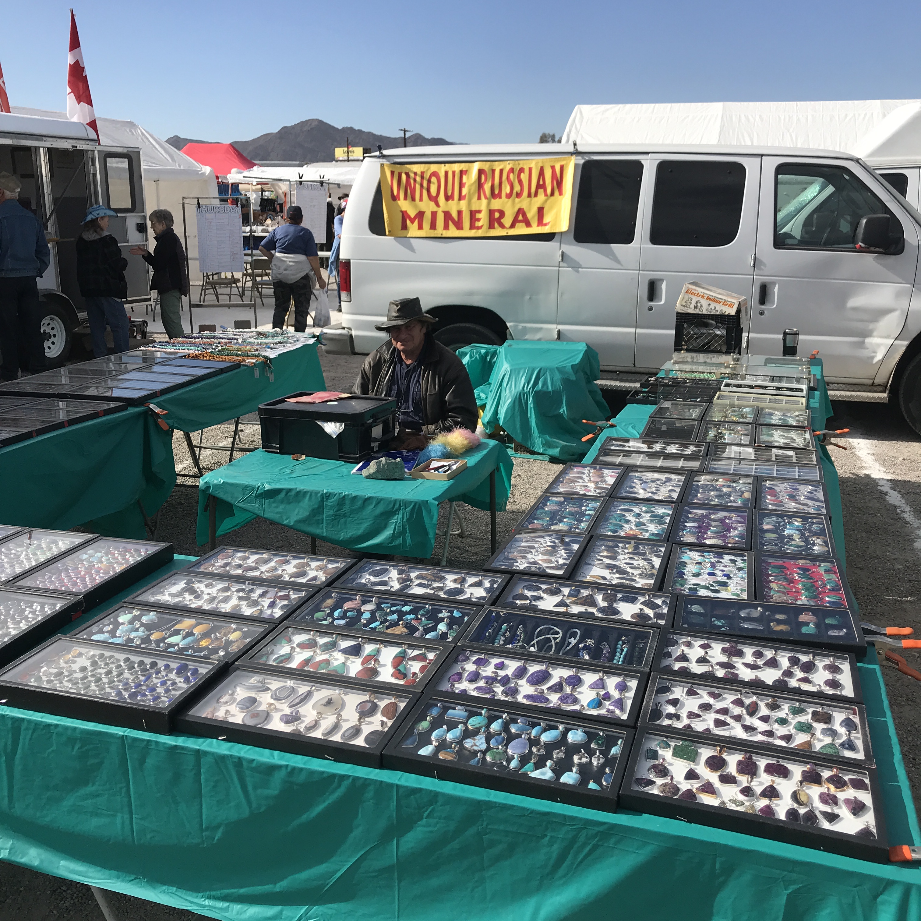
— Alexander Balagula of Unique Russian Mineral at space 326 provided me a chance to try out my rusty Russian. Alexander didn’t correct me on my “Good morning and how are you greeting?” I felt good about that. He showed me some beautiful free form cabs of eudialyte on which he said he founded his business. He lists Fort Lee, New Jersey as his business address and the stone I eventually bought comes from the Kola Peninsula in Russia. To add to that that sense of going around the world, Alexander is a Russian Jew who lived for many years in Israel.
When someone asked him about his sign, Unique Russian Mineral and what it was, he smiled and said it mostly refers to himself. I liked his sense of humor. He will be in Tucson. His business card lists a website and an Etsy page but they don’t easily reflect his offerings. The Etsy store is gemstoneworld. Try his e-mail or these phone numbers. E-mail: [email protected]. Cell phone: 201-647-4211. I had buyers’ remorse about the stone I bought and Alex gave me full credit for the returned cab. I wanted what you see in the photo below but settled for something more affordable on Thursday. Don’t settle or you’ll go through a painful night of reconsideration. Yes, I got that piece with the plume of yellow sphene or titanite on Friday. I understand your jealously. — — At one point I heard Pink Floyd being played on an acoustic guitar being played by a young man who calls himself DanTheCabMan. That’s an Instagram handle for those who don’t know. He played “Wish you Were Here” and I wished every rockhound could be there in Quartzsite, too. In the video he says he won’t sing. I promised I wouldn’t, either.
#danthecabman from Thomas Farley on Vimeo.
— Here’s a photo on Thursday of what I used to call vesicular basalt with peridot. Not particularly wonderful specimens but a teaching moment. I am now told this is more properly termed vesicular porphyritic olivine basalt. Of, course.
—
Practical points. I found my fabric and rubber hiking boots worked very well for walking the aisles. After all, I hike in them all day so it made sense they would work here. Whatever you use, make sure they are comfortable and perhaps have a backup pair in your vehicle in case they don’t. Also, I found getting in touch with people is extremely difficult these days because everyone has their own preferences. Some use a mobile phone, others e-mail, some text, some message by Instagram or Facebook. I don’t have advice on overcoming this but you may want to make arrangements before hand if you are meeting someone in Quartzsite. While the vendors will all be in a certain location, your friends may be bouncing all over towns at different venues. Speaking of which, tomorrow I will be going back to the PowWow for a little bit and then hitting Desert Gardens across the highway later on. Different material, bigger stuff, lots of rough.
Bonus footage! Non-Pow-Wow. I almost forgot Miner’s Depot, a Quartzsite institution. I did a video on them on this second day and they are worth a lot more in print than I have time for here. They are less than a half mile north of city center. Great people. Gold spoken there.
Miners Depot in Quartzsite, Arizona from Thomas Farley on Vimeo.
—
Pow Wow Show Promoters Mike & Carolyn Zinno 928-927-6325 [email protected]
Quartzsite Improvement Association 235 E. Ironwood Avenue, Quartzsite, AZ 85346 http://qiaarizona.org
You can read more about Quartzsite at Rock&Gem’s website and Facebook page. (external link). I was covering the day to day at the PowWow for them this year and I have written extensively on all things Quartzsite in the past. — Follow me on Instagram: tgfarley